


Forêt du Trait- Le Catelier

JMCMoreau
User
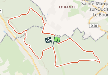

Length
11.9 km

Max alt
125 m

Uphill gradient
217 m
Km-Effort
14.8 km

Min alt
42 m

Downhill gradient
213 m
Boucle
Yes
Creation date :
2022-09-17 14:58:05.379
Updated on :
2022-09-17 14:59:37.138
3h30
Difficulty : Easy

FREE GPS app for hiking
 SityTrail
IGN / Geographical institutes
SityTrail Plus
The world is yours!
About
Trail Walking of 11.9 km to be discovered at Normandy, Seine-Maritime, Le Trait. This trail is proposed by JMCMoreau.
Positioning
Country:
France
Region :
Normandy
Department/Province :
Seine-Maritime
Municipality :
Le Trait
Location:
Unknown
Start:(Dec)
Start:(UTM)
341695 ; 5484863 (31U) N.
Comments